Route 1 Geocache
The Pathway to Gold
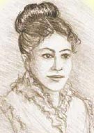
Following Harry/Harriet Collins
Rich in history, scenic beauty and hospitality, the route from Hope to Barkerville has been the Pathway to Gold for thousands of years.
First Nations, fur traders, gold seekers, Royal Engineers and railroaders have all left their mark on this unique landscape. From the Fraser Canyon to the rolling Thompson bench lands and into the Cariboo, the route remains a road to riches of another kind today.
The communities on the Pathway to Gold are part of a living history, not a dead past. You can taste that history at the dozens of sites along the way. You can get your passport stamped at participating Visitor Centres and partner organisations near each site.
June 1, 1866: Arrived by steamboat at Fort Hope. Somewhere up the river is George. I am determined to find him – and to preserve my secret. Mr. York, my cousin, accompanies me.
The bend where the Fraser River turns west has been a special place from the earliest Sto:Lo First Nation settlements 10,000 years ago to today.
Sto:Lo tradition says X:als, the Transformer, came here as he ordered the world. Simon Fraser started a different transformation when he arrived in 1808. The fur trade followed, then the gold rush. But Hope’s welcoming spirit and appreciation of the past has never changed.
Three Fun Facts about Hope
- Hope recaptures its fur trade past during Brigade Days each September. Festivities range from fireworks to the Chainsaw Carving Competition.
- The Hope Museum showcases the area’s history, culture and heritage. Exhibits include First Nations culture, early Fort Hope, the Gold Rush, the Kettle Valley Railway, pioneer life, logging and mining.
- Hope made history as the setting for the Hollywood blockbuster, “Rambo: First Blood,” starring Sylvester Stallone. The Hope Visitors Centre recently celebrated the movie’s 25th anniversary
June 2, 1864: Passed the famous Hill’s Bar. Mr. York much excited and talked long of its rich claims. The town, however, is nearly abandoned and falling to ruin…
Ground Zero of the explosive Fraser River gold rush was known to the First Nations as “Hemhemetheqw,” or “place to make salmon oil.” This 100-metre stretch of gravel was the richest gold-bearing bar on the Lower Fraser. A San Francisco prospecting party led by Edward Hill discovered gold here during a lunch stop in March, 1858. The instant town that sprang up on this rich real estate has completely vanished.
Three Fun Facts about Hill’s Bar
- Hill’s Bar was mined by both First Nations and Americans early in the rush until an argument over a pick ended with Chief Kowpelst of Spuzzum being struck by a shovel wielded by American Con Mooney.
- By an extraordinary coincidence, Gov. James Douglas came upriver at that moment and intervened to defuse the dispute.
- The settlement—packed with hotels and stores, but just one saloon—was briefly home to Judge Ned McGowan, who gained infamy during “McGowan’s War” in 1858–59.
June 2, 1864: Arrived Fort Yale by steamboat. Can George be in such a wild place? So many saloons and gaming houses. But have found a man who claims to know where he is. We have agreed to meet at a more reputable establishment.
Visit Yale and take a stroll down the Grand Boulevard of B.C. history. From a vibrant, 10,000-year-old First Nations culture to colourful gold rush characters, from paving the way to joining Confederation to building a national railroad, it all happened here. Visit sites like the Yale Museum, St. John the Divine Anglican Church and the Chinese Railroad Construction Workers memorial.
For more information about Historic Yale, please visit historicyale.com
Three Fun Facts about Historic Yale
- Archaeologists show a First Nations presence in Yale for nearly 10,000 years.
- The Yale First Nation hosted Simon Fraser in 1808. The Hudson’s Bay Company established a trading post in 1848.
- Yale boomed during the Fraser River Gold Rush of 1858, when Mainland British Columbia became a Crown colony. The 1868 Confederation League’s Yale Convention led to B.C. joining Canada. Yale was also a major hub during railway construction.
June 4, 1864. A very pleasant stretch of road along the “Little Flat.” Mr. York asked for word of George, but so many people are rushing to the Cariboo, it is like looking for a needle in a haystack…
Spuzzum means “Little Flats,” but there’s nothing small about the community’s spirit. Since ancient times, the people of Spuzzum were renowned for being peace-loving. A natural resting place along the Cariboo Wagon Road and later the Trans Canada Highway, it had but a single gas station and general store. Residents made its tiny size a virtue: both sides of a highway sign read “You are now leaving Spuzzum.”
Three Fun Facts about Spuzzum
- Small size, big humour: t-shirts with slogans like “If you ain’t been to Spuzzum, you ain’t been anywhere” and “Spuzzum Institute of Technology” joked about Spuzzum’s size.
- Part of Spuzzum was burned in 1858 during a raid by American miners. But leaders like Chief Kowpelst still advocated peace.
- When the highway reopened after the rebuilding of Alexandra Bridge, the toll was an astronomical $1.00, or about $40 in today’s money.
June 5, 1864: We crossed a very fine bridge indeed and stayed in a fine roadhouse on the far bank. There were any number of natives fishing in the river at the narrows.
In 1861, the original bridge built by Joseph Trutch was the marvel of the Cariboo Wagon Road. The span across the narrows made unimpeded wagon traffic a reality. But by 1912, the wooden structure was gone. It would be 1926 before a new bridge was built to accommodate the Cariboo Highway. The elegant steel and concrete bridge is the centrepiece of the 55-hectare Alexandra Bridge Park.
Three Fun Facts about Alexandra Bridge
- The bridge is named for Princess Alexandra of Wales, wife of the future King Edward VII.
- You can walk across the bridge and on portions of the old Cariboo Wagon Road, the Fur Brigade Trail and ancient First Nations trails in the park.
- Above the bridge on the east bank is Alexandra Lodge, one of the last remaining original Cariboo roadhouses.
June 6, 1866: I can’t imagine how Mr. Fraser and his men made it through such a place… one look down was dizzying…
“Surely this is the gate of hell,” Simon Fraser wrote after his party crossed “where no man ought to venture” in 1808 with the help of the local Nlaka’pamux people. Here, the towering rock walls of the Fraser River plunge toward each other, forcing the waters through a passage only 110 feet wide. Today, the Hell’s Gate Airtram allows you to glide safely where Fraser feared to tread.
For more information about Hell’s Gate, please visit www.hellsgateairtram.com.
Three Fun Facts about Hell’s Gate
- Railway blasting in 1913 triggered a rock slide that partly blocked the river and reduced salmon runs. Elaborate fish ladders were later constructed to restore the runs.
- An aerial tram takes you to the west bank where an interpretive centre, restaurant and other attractions centre on “The Wall,” depicting Simon Fraser’s pervious passage.
- After years of strange goings-on, Hell’s Gate Airtram called in the experts and confirmed the attraction is haunted by a host of friendly ghosts.
June 7, 1864: While were stopped at this place, I discovered George has a partner in a claim here. But the Chinese miner says he has not seen him since early spring. He was “headed north,” perhaps for Barkerville!
The large number of Chinese miners working this bar were from poor farming villages. Coming to “Gold Mountain” was their chance to strike it rich. They believed in peaceful co-existence and during the Canyon War of August, 1858, and were the only miners allowed to stay on their claims by the Nlaka’pamux. The American Militias fighting the First Nations viewed the Chinese with suspicion and forced them to leave their claims just before the peace of Camchin. But they returned and continued to patiently work in harmony with their neighbours.
June 8, 1864: They say this was once one of the busiest gold bars on the Fraser, but it seems very quiet now. The stage broke an axle and we must stay another night.
The ancient Nlaka’pamux village of Quayome has been Action Central since time immemorial. A major village, it got its new name during the 1858 rush. During the Canyon War, the Battle of Boston Bar was fought between American miners and the Natives. Restored peace didn’t mean quiet – the town became a major railway center in the 1880s. Today it’s a busy stop for motorists exploring the historic Canyon.
Three Fun Facts About Boston Bar
- Americans were known in Chinook jargon as “Boston Men.” In 1858, a heavy “Boston” presence coined the current name.
- Live First Nations history at Tuckkwiowhum First Nations Village. This native dude ranch gives a glimpse of First Nations life pre-contact.
- “Boston Bar” used to refer to the west bank of the Fraser. When the railway came through, this area was dubbed “North bend” and Boston Bar moved across the river to the present town site.
June 9: We passed a very pleasant scene just south of The Forks, with rolling fields set against the green mountains. Mr. York is acting very strange. He no longer speaks of the gold mining claims we pass and has grown quiet…
There’s no memorial, or plaque, but one of the most important meetings in Canadian history took place on this spot. In August, 1858, American militia Captain Henry Snyder was marching up the Canyon to Camchin, hoping to meet with the great Nlaka’pamux leader, Chief Spintlum. On the night of August 21, 1858, Spintlum met Snyder and they agreed to a peace, formalized the next morning. Were it not for the courage of these two men, the early history of B.C. would have been very different.
June 14, 1864: Mr. York has news of George at last! He says my dear husband is prospecting up the Thompson River, which is close at hand. Perhaps I shall see him in just a few days…
It’s not just the high temperatures that make Lytton Canada’s “Hot Spot.” The community has been renowned for its warm hospitality since Simon Fraser stopped at the ancient First Nations village of Camchin, which dates back some 10,000 years. At the confluence of the Thompson and Fraser Rivers, Lytton is a rafter’s paradise. It’s also the gateway to nearby Stein Valley Nlaka’pamux Heritage Park, an intact wilderness area full of First Nations spiritual, historical and cultural significance.
For more information about Lytton, please visit www.exploregoldcountry.com
Three Fun Facts About Lytton
- The centrepiece of Caboose Park is Caboose number CN78939. This CN car was built in 1918 and crossed the country countless times before being retired in 1984.
- Known to non-Natives as The Forks, the town (founded in 1858) was eventually named Lytton in honour of Lord Edward Bulwer-Lytton, British Colonial Secretary.
- The Lytton “Jelly Roll” located in Caboose Park displays the circular, layered, roll-like geological formations caused by glacial movement.
June 17, 1864: I am almost discovered! A man burst into my room while I was changing – he had mistaken the number. But I cried “Murder! Robbery!” and he fled, apologizing. Mr. York thought it funny. I do not!
At the junction of the Nicola and Thompson Rivers, Spences Bridge boasts the oldest continually operating hotel in B.C. Built in the 1860’s, the Inn at Spences Bridge has had different names, but always the same hospitable spirit. Residents love sharing local lore over coffee at the Packing House. You can also visit the heritage cemeteries, see the acacia trees planted in the 1800s or see the original Widow Smith house.
For more information about Spences Bridge, please visit www.exploregoldcountry.com.
Three Fun Facts about Spence’s Bridge
- Originally known as Cook’s Ferry, the Thompson crossing began as a rope ferry established in 1859-1861.
- In 1863 Thomas Spence got a contract to build a bridge, but the government ran short of money and allowed Spence to charge a toll to cover costs. It became known as Spence’s Toll Bridge.
- The Packing House was originally an apple packing house for the famed Widow Smith apples, shipped all over the world in the 1800’s and favoured by the royal family.
June 20, 1864: I have never seen so many stagecoaches, cattle or comings and goings! The place seems a riot, but Mr. York assures me this is the normal bustle of business in Cariboo.
The Cariboo earned a rowdy reputation during the gold rush, but Ashcroft proves it wasn’t all saloons and shoot ‘em ups. This cultural capital boasts the Ashcroft Opera House, built in 1889. It’s seen international opera companies, traveling productions, recitals, poet laureates, high society events and silent movies. Find out more by visiting the Ashcroft Museum, where you can learn about the gold rush, First Nations, railway and Chinese history.
For more information about Ashcroft, please visit www.exploregoldcountry.com.
Three Fun Facts About Ashcroft
- You can Walk Through Time at Heritage Park’s interpretive displays, featuring experiences of life in a gold rush shanty, work on a ranch and the railway arrival.
- The Ashcroft Museum has detailed exhibits about the gold rush, mining, agricultural, First Nations, railway and Chinese history.
- When the CP and CN railroads came through Ashcroft, the narrow confines of the geography ensured that the lines were close together, running through the same property, making for perfect train-watching locations.
June 21, 1864: The climate here is quite warm and pleasant. I have been feeling ill the last few days, but Mr. York says I appear well. It is hard, pretending all the time…
Cache Creek’s strategic location makes it the getaway gateway. Located at the junction of two valleys and waterways, it’s proved a natural supply location for First Nations, fur traders and gold seekers alike. A rest-stop on the Cariboo Wagon Road, the junction was an important re-stocking and trading location. Today, this friendly community is the perfect stop-over for travellers who want to explore its attractions in a unique, semi-arid desert climate.
For more information about Cache Creek, please visit www.exploregoldcountry.com.
Three Fun Facts about Cache Creek
- Cache Creek was the site of the last remaining stop sign on the Trans Canada Highway, replaced by a traffic light in 1984.
- The 1950s style Cache Creek Info Centre has a drive-in, malt-shop feel outside and lots of local, regional and event information inside.
- Road warriors roar back to the 1950s during Graffiti Days nostalgia weekend in June. Show and Shines, sock hops, and drag races are all part of this annual event that attracts hundreds from across the Pacific West Coast.
June 22, 1864: Arrived at a very comfortable roadhouse. Feeling better. I would be almost happy were it not for the lack of news about George. The trail has gone cold.
Built in 1861, the original roadhouse had a reputation for comfort and hospitality. The spirit lives on and you can experience First Nations and ranching history at today’s Hat Creek House. The ranch offers visitors a chance to enjoy the artifacts on display or take a stagecoach ride. Or visit the Native Shuswap village and experience stories of mystery, love, murder, success and failure.
For more information on Hat Creek, please visit www.exploregoldcountry.com.
Three Fun Facts about Hat Creek
- Hat Creek junction was renamed “Cargile” after pioneer William Cargile, who operated the roadhouse in 1881. But his name was misspelled “Carqile” on provincial documents. The mistake wasn’t officially corrected until 1987.
- Upper Hat Creek is rich in First Nations lore, with tales of healing plants and miracle waters.
- No visit to Hat Creek is complete without a stop at the B.X. Historical marker at the breathtaking Painted Hills – an iron and mineral rich hillside of special beauty.
June 23, 1864: There was a ball being held tonight, but I dare not go – the temptation to dance is so great. I long to be out of these miner’s clothes. Mr. York keeps telling me how well and independent I look. I feel neither.
“You should see him sprintin’/to the ball at Clinton,/teaming up the Cariboo Road…”
As the songs says, Clinton was the place to be during the gold rush. At the junction of the the Cariboo Trail from Lillooet and the Cariboo Road from the Fraser Canyon, Clinton was the gateway to the gold fields beyond. People still sprint into town for the famous Annual Ball, held every year since 1868.
For more information about Clinton, please visit www.exploregoldcountry.com.
Three Fun Facts about Clinton
- One of the finest collections of Gold Rush and Cariboo history is at the Clinton Museum and Info Centre.
- The awe inspiring Painted Chasm was created 10 million years ago by multiple lava flows and melting Ice Age streams.
- Saddling up and riding off on one of the many back country trails is a tradition. So is the Clinton Country Jamboree, where you can see how our pioneers once lived.
June 26, 1864: Mr. York has abandoned me! He left me a letter saying he must seek his fortune in the goldfields. But I will not give up – I will go on alone!
Imagine teaming up the Cariboo Road by stagecoach, enduring bone-shocking bumps, broken wheels and impatient fellow passengers, anxious to get to the gold fields. Now imagine your relief on reaching the comforts of 70 Mile House, your first significant stop. Built as a roadhouse in the 1860s, today 70 Mile remains a haven for travellers wishing to explore the ranches, resorts and historic gold routes in this glorious region.
For more information about 70 Mile, please visit www.exploregoldcountry.com.
Three Fun Facts about 70 Mile
- 70 Mile House is the gateway to the Green Lake Recreational Area, situated on the famous Fur Brigade Trail between Fort Kamloops and Fort Alexandria.
- In autumn, thousands of Sandhill Cranes pass through on their annual migration.
- A little further up the road, the 83 Mile Farm Equipment Museum. Originally another roadhouse, it now houses artefacts like some of the coaches that travelled the Cariboo Road.
June 30: I saw a man today that looked just like George! I ran over and embraced him, I was so certain. But it turned out to be a French miner! I stammered my excuses, but he simply laughed and wished me luck finding “mon frère…”
If you were bound for Barkerville, 100 Mile House gave you both a rest stop and an important psychological boost. The comforts of the roadhouse were enhanced by the knowledge you’d come 100 miles from Lillooet, the official start of the route. Today, 100 Mile House continues to provide inspiration as a dynamic Cariboo community. The log home capital of Canada, it’s also the gateway to many area attractions.
For more information about 100 Mile House, please visit www.landwithoutlimits.com.
Three Fun Facts about 100 Mile House
- Originally known as Bridge Creek House, the community was renamed after a roadhouse was constructed in 1862.
- In 1930, Lord Martin Cecil arrived from England to manage his father’s estate. The town at the time consisted of the roadhouse, a general store, a post office, telegraph office and a power plant.
- Just up the road, the 108 Heritage Site has a growing number of restored buildings, including the largest log barn in Canada.
July 14, 1864:The child is feeling heavier and heavier. I sought out a Native woman in confidence and she gave me a tea to drink that helps. I am in hopes of a letter from George at our next stop…
Simon Fraser wouldn’t have made it to the Pacific without its chief’s. Its steamship landing allowed thousands of gold seekers to reach Barkerville. And they gave the Grand Trunk Pacific Railway a hand completing the line from Eastern Canada. Soda Creek/Xats’ull’s people have always gone the extra mile for their guests. Return the favour and check out this Secwepemc First Nation community.
For more information about Soda Creek/Xatsu’ll, please visit www.landwithoutlimits.com.
Three Fun Facts about Soda Creek/Xatsu’ll
- Experience Secwepemc spiritual and cultural traditions at the national award-winning Xats’ull Heritage Village. Hear the stories from the elders, enjoy delicious traditional foods or visit the sweat lodge for a real spiritual experience.
- In 1808, Xatsu’ll’s chief guided Simon Fraser all the way from his village to near present-day Lillooet.
- After his wife nearly drowned after falling off the ferry crossing the river, Rudy Johnson found an abandoned bridge in Alaska, shipped it home piece by piece and reconstructed a safe crossing.
July 21, 1864: At last! A letter from George. I had to beg the innkeeper to give it to me, it being addressed to “Mrs. Collins.” George was headed for Barkerville! But the letter is very old. Did he make it?
At the junction of the Fraser and Quesnel rivers, Quesnel boomed as paddlewheelers and pack trains shipped goods and gold seekers through town. By the early 1860s, Quesnel had a telegraph office, grist mill and lumber mill and had the Hudson’s Bay Post. You can still shop in the original Hudson Bay Store, a log structure built in 1859. It’s a community that takes its rich heritage seriously.
For more information about Quesnel, please visit www.quesnel.ca.
Three Fun Facts about Quesnel
- Across the street from the Bay is a Cornish Water Wheel and boilers and iron parts from the first Fraser River riverboat to travel to the city.
- The Quesnel Museum has over 30,415 artefacts and archival items preserved in 11,000 square feet of display space.
- Popular museum attractions include one of the most significant collections of rare Chinese artefacts in North America. Village Street faithfully reflects pioneer life at a general store.
July 25, 1864: No letter here from George, but word he did pass through here! I grow more and more impatient and wonder sometimes if our child will ever know his father.
The roadhouse built in 1864-65 as the first major stop after Quesnel on the last leg of the Cariboo Wagon Road to Barkerville formed the heart of the Cottonwood community. In 1874, the Boyd family took over management and continued a tradition of Cariboo hospitality until 1951. It was used as an office by the Overland Telegraph and some of its poles and wires are still visible. The tiny community of Cottonwood endures and so does Cottonwood House, as dwell as a portion of the original Cariboo Wagon Road that runs right through the property. Today, Cottonwood House is managed by School District 28 (Quesnel).
For more information on Cottonwood House, please visit www.cottonwoodhouse.ca.
July 26: I reflected today on my journey, now it nears its end. I have done things I never thought I would do, and traveled all the way from Victoria to here dressed as a man. Despite all the hardships, I am almost sorry it is over…
Wingdam sat on Lightning Creek, in the heart if one of the richest gold fields of the Cariboo. The creek got its name from Bill Cunningham, who was in a party of prospectors who had a particularly grueling journey from Antler Creek. Cunningham, ever the optimist, would fire up his tired companions whenever they were discouraged by exclaiming: “Boys, this is lightning!” On arriving near Wingdam, the party dubbed the stream Lighting Creek after Cunningham’s favorite phrase. But in this case, lightning didn’t strike – they found no gold. Just a short time later and a short distance away on Van Winkle and Last Chance Creeks, spectacular gold finds were made. But in the 1930’s, a new mining operation struck it rich. A town of several hundred people grew around the mine, but when the main shaft flooded in 1937, the mine was closed and the town soon disappeared.
July 27, 1864: There was a letter here, but not from George – from Mr. York! He begs my forgiveness, but claims to have struck it rich! He has offered to pay for the baby’s clothes, etc. Hints I should give the child his middle name if a boy. Cheek!
In 1862, E.F. Edwards and W. “Bloody” Edwards (an Englishman who acquired his nickname by frequently using the world “bloody”) built a stopping house here on Lightning Creek. In 1868, they sold to J. Hamilton who gave it the name Pinegrove. It was one of 12 roadhouses built along the road between Quesnel and Barkerville during the 1860s. Today, Pine Grove House is just a memory.
Built in the early 1860s, the log cabin structure at Beaver Pass was one of the most important roadhouses on the way to storied Barkerville. In 1869, George Hyde and his wife bought out the previous owners and became its first permanent residents. Hyde had other talents aside from running the ranch: he was known as a talented taxidermist. Hyde succumbed to tuberculosis in 1878. His wife sold the house in 1880 to John Peebles of Stanley. Peebles owned the property for 20 years, making many improvements to the ranch and roadhouse. After Peebles’ death in 1899, a series of managers kept the house running until the 1930s. It didn’t long survive abandonment in the harsh Cariboo winters and heavy snows and neglect soon spelled its collapse.
July 28, 1864: This is a wild place! Miners simply throw their money away at the tables like it was water. I have never seen so much gold in one spot. If George has squandered such a fortune, I don’t know what I’ll do—if I find him.
Stanley was named after Edward Stanley, Early of Derby and Colonial Secretary (his brother, Baron Stanley, was the Governor-General of Canada who lent his name to Vancouver’s Stanley Park). Once crammed with saloons that saw some of the millions of dollars worth of gold that flowed out of nearby claims, all that remains today is the cemetery. It’s worth the visit: here lay some of the Cariboo’s characters, like Josiah Beedy, a partner in the famed BX Express, who brought in the first “road steamers” to brave the Cariboo Road—with disastrous results.
July 29, 1864: I don’t know if I can stand it. Now we are nearly at Barkerville, and what if George is not there after all?
The Cariboo gold rush was long over and the world was in the grips of the Great depression when Fred Wells made one of the first hard rock gold discoveries in B.C. He founded the company town of Wells at the head of the Willow River and developed the Gold Quartz Mine, prompting the “Second Cariboo gold rush.”
For more information about Wells, please visit www.wells.ca.
Three Fun Facts about Wells
- Fred Wells was born in New Hampshire in 1861. One story says he came to B.C. in 1882 by crossing the Rocky Mountains from Calgary on an Indian pony “just to see what lay on the other side of the mountains.”
- The town of Wells was a bustling community of 3,000 at its peak in 1940. Much smaller today, it blooms again in summer as a busy arts and recreation centre.
- The Wells Museum offers an exploration of the area’s history, including hard rock mining and thirties recreation.
July 31, 1864: Joy! Walked into a barber shop and there was George getting his hair cut! He has sent letter after letter, but none reached me. Afterwards, I told him of the baby. He laughed and told me to change my trousers for a gown.
Triumph and tragedy. Gold beyond the wildest dreams. Love, murder and mischief. Barkerville is as rich in lore and stories as it once was in gold. And the best part is you can still experience it firsthand. Walk down the wooden sidewalks of the town Billy Barker made famous, take in a show or pan for gold in this living history site.
For more information on Barkerville Historic Town, please visit www.barkerville.ca.
Three Fun Facts about Barkerville
- Billy Barker’s gold discovery at Williams Creek in 1862 started a stampede that saw, over 100,000 people travel the Cariboo Wagon Road between 1862-1870.
- Fire destroyed Barkerville in 1868. But the town was rebuilt and today, you can experience over 125 heritage buildings, including a Chinatown.
- Theatre Royal puts on stage shows. Performers in period costumes provide street theatre and special events throughout the summer bring Barkerville and the Cariboo gold rush alive.